Conundrum Solved: Training Walls
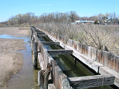
The odd bulkheaded canal, as I termed it in an earlier post, has a name: training walls.
A knowledgeable government employee sent me the following explanation. Read it and you're bound to think of the old Barry Commoner maxim that everything is connected to everything else. This chart will situate Sandy Point and Old Field Creek; Morse Beach and Point are due south of Sandy Point and depicted with broken lines.
Many many years ago, the City of West Haven relocated the outlet channel to Old Field Creek, from a more easterly point to the current location and installed a tide gate to drain the marsh above Beach Street, perhaps for mosquito control purposes.
The outlet would plug with sand, which is typical of such drainage structures in sandy locations like this -- with active sand deposition and alongshore drift (easterly in this case). With the sand in the way, the gates would not open and the marsh above would flood or impound freshwater. It was the ebb and flow of the tides the create currents to maintain open channels through these beach systems. Tide gates eliminate the inflow of the tides and allow for drainage of any accumulated freshwater in the marsh to flow to the Sound at low tide. The meager discharge of freshwater could not prevent the accumulation of sand and so the outlet became plugged with sand.
To solve this new problem, the City constructed these training walls -- seaward beyond the beach into the shallow waters of the Sound. The training wall would convey water directly to the Sound but any structure perpendicular to a beach acts as a groin, promoting deposition on one side and erosion on the other. In this instance, the sand that was flowing eastward met the western training wall, which is where deposition occurs. This deposition continued until the beach prograded seaward to the very end of the training wall. Then the sand began to form a spit below the outlet and this spit grew towards New Haven Harbor forming today what is known as Morse Beach.
Simulataneously, the training wall interrupted the supply of sand to the ancient barrier known as Sandy Point and so Sandy Point entered an erosional phase. Under Sandy Point lies the city's sewage treatment outfall pipe. The erosion became so severe to the beach that it uncovered the pipe and the pipe was then capped with concrete blocks. Morse Point grew towards Sandy Point, creating first a lagoon or embayments between the two beaches; later, as shoaling continued, tidal marsh vegetation became established. The inlet to the harbor became narrow and the current velocities increased and scoured sand from the pipe, necessitating periodic dredging and widening of the inlet.
DEP has been working with the City to devise a restoration plan for Old Field Creek salt marshes. This would be accomplished through increasing tidal flow to the marshes.
The current plan is to eliminate the existing tide gates and install self-regulating tide gates (adjustable floats that allow the ebb and flow of the tide but that close if the water levels on the downstream side exceed an elevation that could cause upstream flooding of roads, for example). The plan also includes the removal of the dysfunctional training walls, and the 'realignment' the tidal creek so that it is more hydraulically efficient -- that is, has a more direct route between Beach Street and the Morse Point outlet.
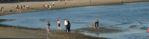
If you scroll down through the April archives, you'll see my previous query about the "canal" and two posts about Sandy Point.
(I should add that government employees are wary of getting their names in print, even in a blog whose readership on a good day reaches the high two figures, so unless they tell me specifically to identify them, I let them remain anonymous; you'll have to trust me that I believe they know what they're talking about.)
A knowledgeable government employee sent me the following explanation. Read it and you're bound to think of the old Barry Commoner maxim that everything is connected to everything else. This chart will situate Sandy Point and Old Field Creek; Morse Beach and Point are due south of Sandy Point and depicted with broken lines.
Many many years ago, the City of West Haven relocated the outlet channel to Old Field Creek, from a more easterly point to the current location and installed a tide gate to drain the marsh above Beach Street, perhaps for mosquito control purposes.
The outlet would plug with sand, which is typical of such drainage structures in sandy locations like this -- with active sand deposition and alongshore drift (easterly in this case). With the sand in the way, the gates would not open and the marsh above would flood or impound freshwater. It was the ebb and flow of the tides the create currents to maintain open channels through these beach systems. Tide gates eliminate the inflow of the tides and allow for drainage of any accumulated freshwater in the marsh to flow to the Sound at low tide. The meager discharge of freshwater could not prevent the accumulation of sand and so the outlet became plugged with sand.
To solve this new problem, the City constructed these training walls -- seaward beyond the beach into the shallow waters of the Sound. The training wall would convey water directly to the Sound but any structure perpendicular to a beach acts as a groin, promoting deposition on one side and erosion on the other. In this instance, the sand that was flowing eastward met the western training wall, which is where deposition occurs. This deposition continued until the beach prograded seaward to the very end of the training wall. Then the sand began to form a spit below the outlet and this spit grew towards New Haven Harbor forming today what is known as Morse Beach.
Simulataneously, the training wall interrupted the supply of sand to the ancient barrier known as Sandy Point and so Sandy Point entered an erosional phase. Under Sandy Point lies the city's sewage treatment outfall pipe. The erosion became so severe to the beach that it uncovered the pipe and the pipe was then capped with concrete blocks. Morse Point grew towards Sandy Point, creating first a lagoon or embayments between the two beaches; later, as shoaling continued, tidal marsh vegetation became established. The inlet to the harbor became narrow and the current velocities increased and scoured sand from the pipe, necessitating periodic dredging and widening of the inlet.
DEP has been working with the City to devise a restoration plan for Old Field Creek salt marshes. This would be accomplished through increasing tidal flow to the marshes.
The current plan is to eliminate the existing tide gates and install self-regulating tide gates (adjustable floats that allow the ebb and flow of the tide but that close if the water levels on the downstream side exceed an elevation that could cause upstream flooding of roads, for example). The plan also includes the removal of the dysfunctional training walls, and the 'realignment' the tidal creek so that it is more hydraulically efficient -- that is, has a more direct route between Beach Street and the Morse Point outlet.
If you scroll down through the April archives, you'll see my previous query about the "canal" and two posts about Sandy Point.
(I should add that government employees are wary of getting their names in print, even in a blog whose readership on a good day reaches the high two figures, so unless they tell me specifically to identify them, I let them remain anonymous; you'll have to trust me that I believe they know what they're talking about.)
posted by Tom Andersen at 6:28 PM
![]()
![]()


0 Comments:
Post a Comment
<< Home